Analysis of the Peralta Map
By Richard A. Robinson
In my 1977 book Why Me? Conquest of the Lost Dutchman Mine, I briefly discussed my interpretation of a map presented in the book The Killer Mountains by Curt Gentry. The alluded to map is a map generally referred to as the “Peralta Map” and the copy shown in the book was purporting to be the actual map (or a tracing of the actual map) given to Erwin Ruth who then gave it to Mr. Glenn Magill. The subject of Mr. Gentry’s book is, of course, Mr. Magill’s search for the Lost Dutchman Mine using the Peralta Map. Since my intention here is to amplify my rather sparse remarks about the physical map drawing itself plus the ambiguous historical nature of the map, I will be avoiding to a great extent discussing the historical aspects of the map. Mr. Glenn Magill implies that his map is the “original”; however, a number of versions of the map seem to exist - one of which is shown on the title page - that vary marginally from Mr. Magill’s map as shown in the 1977 paper back version of The Killer Mountains. Some of the renderings actually contain variations which, according to my analysis presented below, more accurately illustrate the physical geographical area represented by the map. What are some of these differences?
Some of the differences pointed out in the following pages might seem a little trivial or hair splitting; however, it is some of these minor differences which permitted the large range of interpretations to have been made. For example, if Mr. Magill’s map contained the heavy shading shown on the map in the book Superstition Mountain, a ride through time it would have been nearly impossible for him to have reached the conclusions that he did that part of the drawing represented a mountain. These minor differences also demonstrate that these maps are not the same map although it is possible that one might be a copy of the other and was modified during the copy process.
The map presentation on the title page is essentially identical in every respect to the one presented in Mr. Gentry’s book, which he refers to as MAP A (see Figure 2), except for the following MAP A differences:
1.The term MAPA DEL DESIERTO is written to the right of the circle symbol.
Note how the letters of the words are the same:
 Figure 2 Word comparisons
2. The word water is written under the word AGUA.
3. The term E. TO W. TO N TO S is written under the arrow and 15000 figure
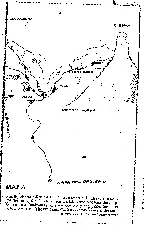 Figure 3 MAP A
There exist two other interesting map variations which contain some fascinating and important alterations and/or additions to MAP A. The first one is one which appeared in the book The Curse of the Dutchman’s Gold by Helen Corbin (1990). This map shown below is also said to be the map given to Erwin Ruth!
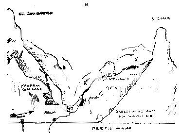 Figure 4 Map from the book The Curse of the Dutchman’s Gold
The major differences between this map and MAP A being:
1. This map shows more shading in the Caverna Con Casa area.
2. This map contains more shading below the term ESCARDADIA.
3. This map contains a line above the term PERFIL MAPA.
4 This map contains the words SIERRA MAS ALTA EN MEDIO DE.
5. This map does not show the lower portion of the map shown in MAP A.
The second map variation was published in the book Superstition Mountain, a ride through time by James Swanson and Tom Kollenborn (1981) which is shown below:
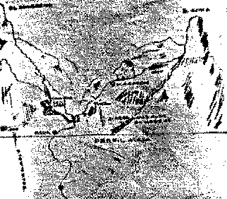 Figure 5 Map version #2
Although the quality of the reproduction in the book is poor, the major identifiable differences between this map and MAP A being:
1. On this map, the term Caverna Con Casa is located to the right of the cave.
2. This map contains extensive shading below and to the right of ESCARDADIA.
3. This map contains a line above the term PERFIL MAPA.
4 This map contains the words SIERRA MAS ALTA EN MEDIO DE.
5. On this map, the term AGUA is closer to the circle symbol.
6. On this map, the term hoya is spelt hoyo.
Also notice that the terms PERFIL MAPA and SIERRA MAS ALTA EN MEDIO DE are located in a different spot than the terms on the map from the Curse of the Dutchman’s Gold book. Thanks to Greg Davis, Director of Research, for the Superstition Mountain Historical Society I was able to obtain a copy of the original of the above map which is produced below:
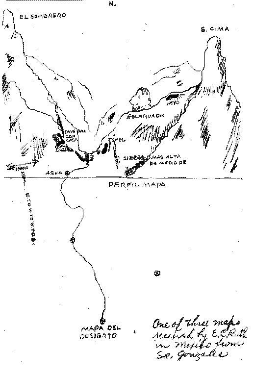 Figure 6 Superstition Mountain Historical Society copy.
From this we are able to see that other differences include:
1. The term E. TO W. TO N TO S is written E. TO W. TO W. TO S..
2.The term MAPA DEL DESIERTO is written to the under the circle symbol.
3. The term S. Sima is written S. cima.
4. The D below the 15000 is not connected to the squiggly line below it.
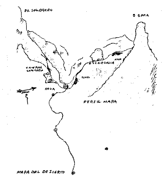
Confusing? You bet! But let’s explore the map in greater detail in relationship to the actual terrain and maybe it might be possible to determine which of these variations more closely defines the situation - that is - if any of them do. However, where should we start? It seems fairly obvious that this map is a fragment or expansion of some other map by the term MAPA DEL DESIERTO or “map of the desert” which is referencing some other map. Is anything known of this “map of the desert”? Mr. Glenn Magill provides such a map in the book Killer Mountains which he claims he received from Erwin Ruth. He refers to this map as MAP B which is shown below.
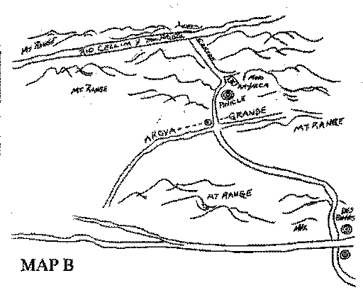 Figure 7 Killer Mountains’ MAP B
The map contains a hodgepodge of English, Spanish and apparently pseudo Spanish terms. While it is an interesting map and might even provide the important clues to being able to read the Peralta Map, there is little doubt that this could not have been an “original” and must represent some rough copy of some other document. For the present, let’s make the assumption that this map is - for the purpose of directions - a reasonable copy of some accurate authentic document.
But before going into more analysis of this map, I would like to comment on a statement and footnote made in the book Killer Mountains. The statement is (page 113):
Maps to the Lost Dutchman are not uncommon. In fact, there are several Phoenix men who have found their bonanza in the manufacture and sale of such “authentic” maps to gullible greenhorns.*
Where the * refers to the footnote:
*Most common is the so-called “Walker-Wiser” map, sold for whatever the traffic will bear. What is never mentioned is that this is one of the grander hoaxes perpetrated by the late Tom Weedin, an Arizona newspaper editor known for his fine sense of humor.
According to the tale, Jacob Wiser did not die when his partner shot him but stumbled out of the mountains to the ranch of Dr. John D. Walker, where, gasping his last breath, he drew a crude map with directions to the mine.
In investigating the story, several things bothered Magill: one was why the wounded Wiser chose the Walker ranch - since en route from the Superstitions he would have had to pass through three other ranches and a town; another was why Walker never attempted to use the map; and last, but not least, the fact that the Walker family had never heard the tale, until the time Weedin first told it, after Dr. Walker was dead.
While there are a number of points made in this footnote (and I won’t be addressing them all), the implication that the Walker-Wiser map is a hoax needs to be addressed. Tom Weedin, in 1911, drew from memory (after more than twenty years) for Sims Ely the map which he had originally been shown and was allowed to make a tracing of by his friend Dr. John D. Walker. This drawing, part of Jim Bark’s documents, is shown below:
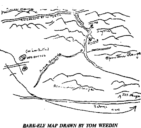 Figure 8 BARK-ELY MAP
How interesting that “one of the grander hoaxes” drawn more than fifty years before Mr. Magill acquired his “authentic” map closely resembles his “real” map? What does this mean? Are they both fakes or are they both rough copies of some original document?
As for “why Walker never attempted to use the map”, a rational review of either of the above maps should provide the answer. Just ask yourself - assuming you don’t have gold fever - would you spend time looking for the mine with such feeble directions, especially given the remoteness and hostile conditions of the location specified?
The general directions specified on either map give directions which, I believe, most researchers agree goes from the Gila River (Des Buttes is today North and South Butte situated on the Gila River about five miles east of Florence) toward the Superstition Mountain and then enters into the south side of the Superstition Mountain at Miners Needle (Pinicle). The directions then signify to follow a northerly running canyon which enters into a major east-west canyon. The only candidate in the Superstition Mountain for the major east-west canyon is La Barge Canyon. I suggest that the best if not the only candidate for the northerly running canyon is Bluff Spring Canyon for two basic reasons: (1) Bluff Spring Canyon is entered directly from the Miners Needle entrance and (2) La Barge Spring is at the intersection of Bluff Spring and La Barge Canyon which agrees with the spring indication of the MAPA DEL DESIERTO on the Peralta Map. Thus, the details within the Superstition Mountain would be:
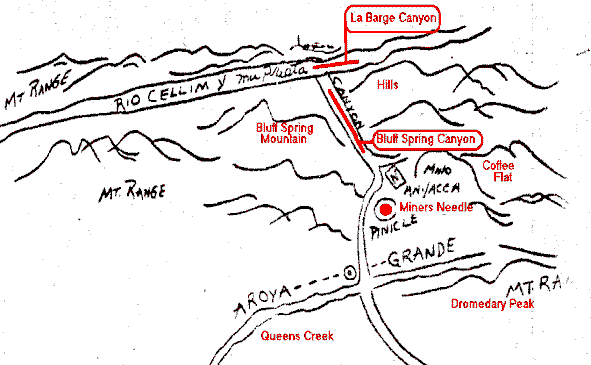 Figure 9 Details of MAPA DEL DESIERTO
An interesting point on both maps is that as the trail passes Miners Needle it passes the Needle on the west side. The trail passing Miners Needle today passes on the east side and from my study of the Geological Survey maps it doesn’t seem possible that a trail would have ever passed on the west side.
So, now it is possible to understand that the MAPA DEL DESIERTO on the Peralta Map refers to the spot in La Barge Canyon where Bluff Spring Canyon junctions with the canyon. From this point more detail is required to traverse toward the mine, and so the map from the MAPA DEL DESIERTO symbol to the AGUA symbol (and slightly beyond) describe in explicit detail the nature of La Barge Canyon. Let’s isolate this section of the Peralta Map and fill in some of the details:
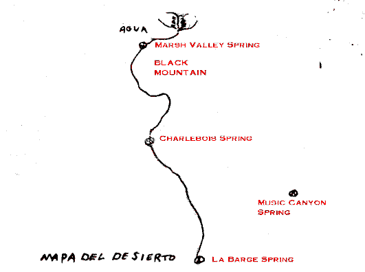 Figure 10 La Barge Canyon detail
After following La Barge Canyon this distance, what happens? One has arrived at the Marsh Valley - Squaw Canyon area of La Barge Canyon and in looking around two things are discovered!
First one looks up Squaw Canyon to the north and sees high up on the wall of the canyon not just a cave but the cave depicted on the Peralta Map. The shape of the cave is exactly as drawn and if you could look into the past you would also see the Casa which, until recent times, existed in the cave.
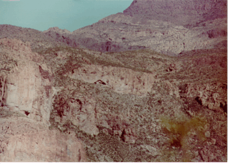 Figure 11 Looking north into Squaw Canyon.
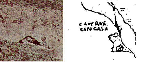 Figure 12 Close up of cave
Next, one looks back up La Barge Canyon sees the box of Squaw Canyon and Black Mountain on the north side of the La Barge. These structures are not just mountain edges but the mountain edges depicted on the Peralta Map.
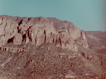 Figure 13 Looking back down La Barge
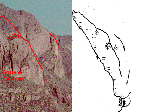 Figure 14 Highlighted features
It at this point that the transformation occurs! At one moment you are an individual following a lifeless map and suddenly at the next moment you are magically placed into a scene which someone drew so many years before! Suddenly you realize that the term PERFIL MAPA refers to the total drawing above the line draw on the two variations of the map. The Peralta Map is actually two maps with two different orientations! The PERFIL MAPA, the part of the drawing above the line, is a visual representation of the terrain drawn from some vantage point in the region of the mine. But where would this point be? There are two aspects of this point that you know must be true. First, from the location of the drawing, one must be able to look down La Barge Canyon and see the cave in Squaw Canyon and also Black Mountain. Second, this portion of the view must appear to the far left of the total view as seen from the point of the drawing. For these conditions to hold one MUST travel in a southwest direction from Squaw Canyon. Since the arrow, the 15000 and E. TO W. TO N TO S are ambiguous and their relevance to the present situation is unknown, let’s ignore their importance for now and try using a Geological Survey map to determine what we need to do.
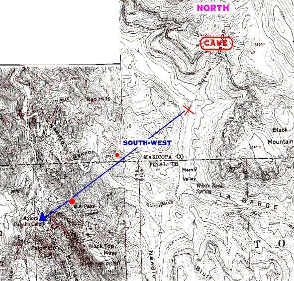 Figure 15 General direction of travel
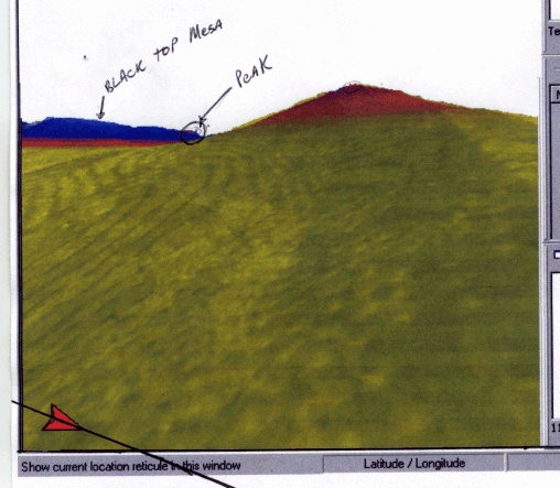
But what should one look for in that direction? A natural answer suggests itself that one should look for some high point from which to make a panoramic drawing. In discussions with several friends who know Spanish very well, it has been suggested that the term SIERRA MAS ALTA EN MEDIO DE where sierra is range, mas alta is highest or high point and en medio de is between, while the terms do not form a true sentence, could suggest a high point amongst smaller ones in a range. The two red dots on the above map are two such locations where the one furthest from Squaw Canyon is the highest and in fact is the location which I suggest is the place where the PERFIL MAPA was drawn. The following photograph is of the location on Black Top Mesa:
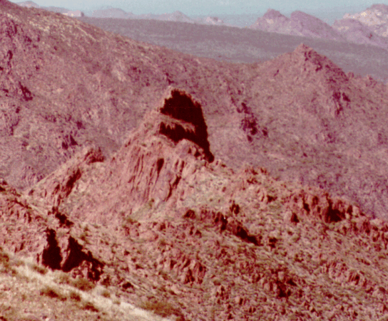 Figure 16 Peak on Black Top Mesa
The following isolates the location where I suggest the drawing was made:
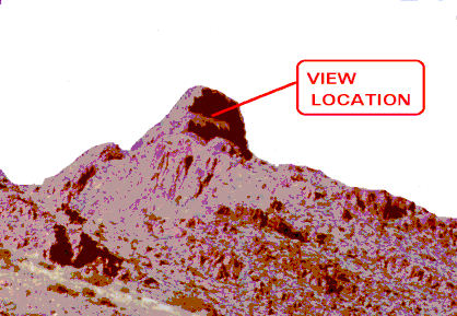 Figure 17 Location
A closer look at this location and a discussion of some of the problems associated with drawing the PERFIL MAPA is necessary to gain a full appreciation of the information imbedded in the drawing. This area is shown in the following Geological Survey map:
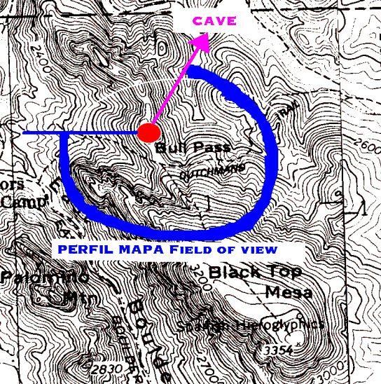 Figure 18 Location showing field of view
The blue partial circle shows the area depicted by the PERFIL MAPA. Notice that this is a very large field of view - almost 3/4 of a full circle! Trying to draw this large of a field of view onto a flat piece of paper creates an insurmountable problem if the artist does not draw a three-dimensional representation of the area. If the artist does not have the skills or the desire to draw a “true” representation, what does he do? The easiest thing to do is to leave out or scale down some of the panorama which is unnecessary or unimportant for communicating meaningful information. It will be demonstrated that this is indeed what the creator of this map has done. Let’s look at the PERFIL MAPA - as drawn from this location - for a moment:
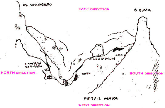 Figure 19 PERFIL MAPA with directions
The cardinal directions have been added to the picture. EAST is “looking” into the picture (is it possible that the term E. TO W. TO N TO S is the indication of this orientation - where the E. means EAST .(into) and WEST .(out of) the drawing?). By breaking the picture down into segments it will be possible to show how the artist compressed this large panorama area onto this flat piece of paper. Let’s first look at an area already covered - looking east down La Barge Canyon:
 Figure 20 Looking east down La Barge Canyon
We see, of course, the cave in Squaw Canyon and Black Mountain ... but wait .. what about that small peak on the south side of La Barge just opposite Black Mountain! What peak ? This one!
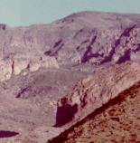 Figure 21 Peak
It exactly matches the peak indicated on the PERFIL MAPA! Look!
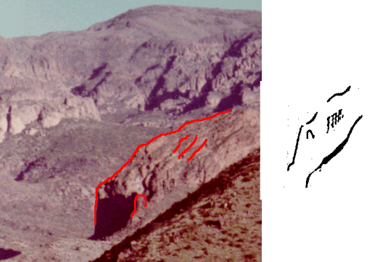 Figure 22 Highlighted peak
What accuracy .. Absolutely amazing.
The next segment is the portion of the panorama looking directly EAST shown in the following photograph.
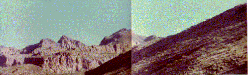 Figure 23 Looking directly east toward Bluff Spring Mountain (2 miles away)
It is in this section that the artist conserves the most field of view. This section is portrait by isolating only that part of this section which is paramount to describing exactly where the mine is located.
This portion of the Peralta Map is :
 Figure 24 Isolated portion of Peralta Map
This drawing isolates the following portion of the view:
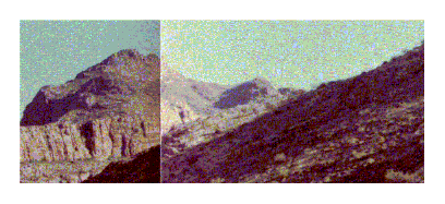 Figure 25 Area depicted
Removing some of Bluff Spring Mountain from the background and highlighting this area to illustrate this affinity we have:
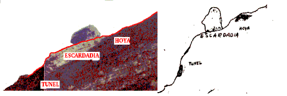 Figure 26 Highlighted features
Arguments have raged about the term ESCARDADIA and it’s meaning but these arguments fall by the wayside when the simple question “what does the terrain say that it means?” is asked. Where the term rests on the drawing is an escarpment on the hill side. The Spanish word for escarpment is escarpadura and the word for steep or craggy is escarpado, -da. ESCARDADIA must have meant one of these two terms which, at a minimum, means that the D after the R must really have been a P! In addition, the Spanish word hoyo means pit; where as, hoya does not seem to have any Spanish translation. So, hoyo must be correct as it indicated the upper shaft of the mine.
The final segment is the segment which looks to the south. This segment is depicted on the Peralta Map by the following portion (notice that I am using the version from Tom Kollenborn’s book):
 Figure 27 South segment
The view to the south is:
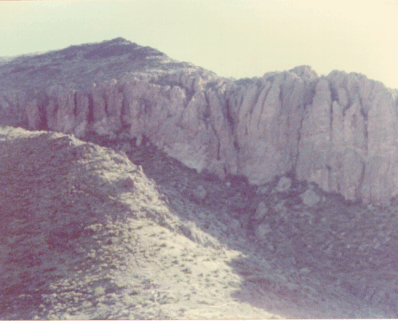 Figure 28 View to the south
Highlighting the areas of interest bring to life the structures depicted by the drawing:
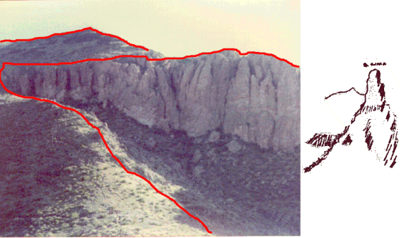 Figure 29 Highlighted south view
It also becomes obvious that the term sima was intended not cima as the meaning of the Spanish word sima is chasm or fissure and the meaning of the word cima is top, summit; hilltop.
In preparing the above image for this document, an interesting point occurred to me (reluctantly and thanks to Dan Kinnard who has a very good artistic eye). This point being:
All of the previous demonstrations of similarity between the drawing and the physical situation have agreed to an extremely high degree, so why does this particular view, while obviously the object of the drawing , not agree in orientation?
The difference in orientation never bothered me as I had felt that is was simply because the field of view was greater that 180 degrees; however, reviewing the following highlighted Geological Survey map of the area suggests a possible answer to the question. That answer being that the location which I have suggested as the viewing location is the wrong location! The location highlighted in blue is the suggested new location.
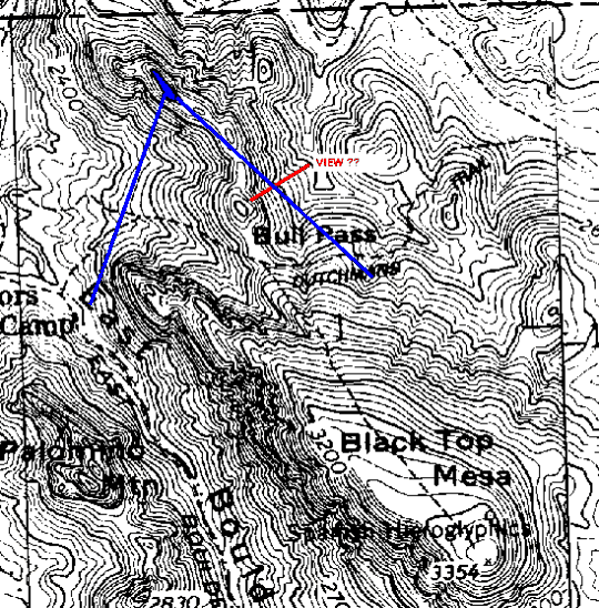 Figure 30 Suggested new viewing location (blue)
While this location is not far from the originally suggested spot, the view up Bull Pass changes dramatically and would have the perspective as shown in the drawing. This is shown in the following highlighted illustration:
 Figure 31 New view of Bull Pass
From this new location the view down La Barge Canyon would be basically the same; however, the panoramic view is now less than 180 degrees making the drawing of the profile map easier. Another important point is that this hill is larger and higher than the originally suggested location and is visible from La Barge Canyon where as the other location is not. The question which still needs to be answered is “does the ‘head’ from Bluff Spring Mountain fall above the escarpment?”from this location. To resolve this question requires another trip into the Superstition Mountain.
While it might be foolish to attempt to decode the “arrow” symbol with the present amount of information available, I would like to share some observations I have made.
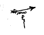 Figure 32 arrow symbol
One observation is that if the shaft of the arrow is extended the extended line touches the caverna con casa and the tunel:
 Figure 33 arrow shaft extended
This extended line makes a 12 degree angle with the base line. This is true of the several versions:
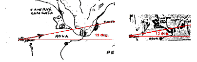 Figure 34 Angle agreement between versions.
What could this mean?
There are any number of possibilities. One possibility that I have been exploring is that the maker of the map is saying that the mine tunnel is in a direction 12 degrees west of south from the caverna con casa. The problem with this particular solution is that preliminary very course measurements that I have made suggests that the direction of the tunnel from the cave is about 30 degrees west of south. Of course this is “true” south and it is probable that magnetic north was the reference which would mean that the tunnel would be about 16 degrees (30 degree minus 14 degree correction) west of south.
==============================================================
ADDITIONAL NOTES August 24, 2002
Utilizing a software program (Manifold Graphic Software) to study the area between the Hill where the major drawing was performed and the Squaw Canyon area, I noted the relationship shown in the following image (north is at the top). The red dot at the start of the of the angle lines is the suggested location where the profile map was drawn :
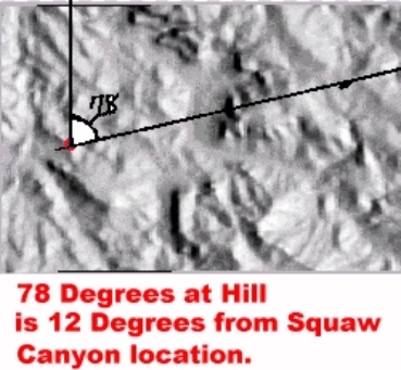
If La Barge Canyon and the cave in Squaw Canyon are highlighted:
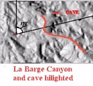
Note the similarity where it crosses La Barge Canyon:
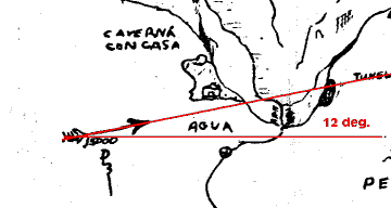 Figure 37 arrow shaft extended
And if you would come out of La Barge Canyon at this point one’s view would be similar to the following false color graphic reproduction of the terrain. Note that the hill in question is just visible “amongst a confusion of lesser peaks”: